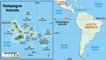
Map of the Galapagos
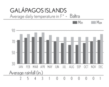
The Galapagos Islands; an archipelago (chain of islands) of wonder. This four million year-old chain of islands is very unique in it's origin, and physical make-up. They're formed by what we call 'hot spots', or volcanic regions that lie on, or near tectonic plate boundaries. As the tectonic plates move along the hotspot, magma burns through the earth's mantle to reach the surface. Since the magma comes up from the sea-floor, the water cools it, and turns it into land mass. Though the Galapagos are pretty much smack dab on the equator, their climate differs, mostly due to the number of different currents that meet in such a small (comparatively speaking) area. Technically speaking, the archipelago is that of a Tropical Savanna (Aw) climate, but many consider it to be an Equatorial climate, due to the number of currents, weather patterns, etc, that can influence it's atmospheric conditions.
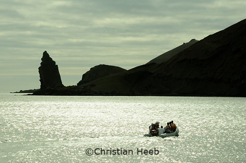
Tuff cone on Bartolome Island
Galapagos of the Future
1,000 years:
For the most part, despite the rapid evolution of the islands, the Galapagos will look much the same in one thousand years as it does now. There will be a couple changes to the landscape, though minor in the grand scheme of things. The floors of valleys (like ones on Isabela Island) will deepen, due mostly to the downcutting of the V-shaped valleys by streams. Also, weathering (and some erosion) will have its place in the shaping of the islands. Tuff cones, like the one seen above, will be weathered over time, mostly by seawater.
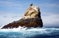
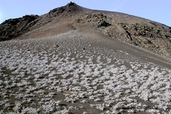
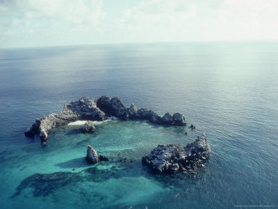
Devil's Crown Atoll, off of Floreana Island
10,000 Years:
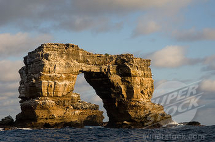
In ten thousand years, the overall physical evolution of the Galapagos will be much more prominent. Weathering and erosion will continue, though mostly by the sea (weathering). The wind alone won't do much to change the physical appearance (as it's too weak), and the islands are rarely hit with intense storms. Atolls (above) are basically coral reefs surrounding lagoons. They will 'begin' their process in the Southeastern most islands, due to the collapse of the land mass itself. The process by which islands turn into atolls was first theorized by Darwin himself, who, ironically enough, spent a great deal of time studying the Galapagos and it's wildlife. The process by which this happens can be seen in the diagram below.
In ten thousand years, the overall physical evolution of the Galapagos will be much more prominent. Weathering and erosion will continue, though mostly by the sea (weathering). The wind alone won't do much to change the physical appearance (as it's too weak), and the islands are rarely hit with intense storms. Atolls (above) are basically coral reefs surrounding lagoons. They will 'begin' their process in the Southeastern most islands, due to the collapse of the land mass itself. The process by which islands turn into atolls was first theorized by Darwin himself, who, ironically enough, spent a great deal of time studying the Galapagos and it's wildlife. The process by which this happens can be seen in the diagram below.
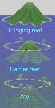
Process by which an island, and the reef around it, become an atoll
1,000,000 Years:
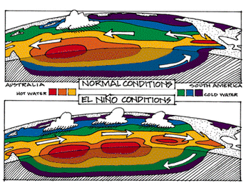
Islands (such as Espanola) will, by this time, either become completely extinct, or will have completed the process by which an island becomes an Atoll. Since many of the Galapagos reef systems have been severely damaged by El Nino, it's unclear how prominent these reefs will be this far down the road (chain). By this time, the actual location of the islands will have moved about 30 miles E-SE, along with the movement of the Nazca tectonic plate. As time goes on, the older islands will (SE) continue to decrease in incline, due to weathering and erosion, while the younger ones start out steeper.
Islands (such as Espanola) will, by this time, either become completely extinct, or will have completed the process by which an island becomes an Atoll. Since many of the Galapagos reef systems have been severely damaged by El Nino, it's unclear how prominent these reefs will be this far down the road (chain). By this time, the actual location of the islands will have moved about 30 miles E-SE, along with the movement of the Nazca tectonic plate. As time goes on, the older islands will (SE) continue to decrease in incline, due to weathering and erosion, while the younger ones start out steeper.
In conclusion, due to the nature of the islands birth, they are more susceptible to change. Charles Darwin came to these islands seeking knowledge on his idea of biological evolution, and found it. Now, using the past, and present, hopefully we can come to a better idea of what this beautiful archipelago might look like in the future, near and far.
- http://www.surtrek.com/sustainability/galapagos-trekking-tour-13-days/
- http://www.galapagos-cruises.ca/island/devilscrownships.html
- http://heebphoto.photoshelter.com/image/I0000GUMccVtHznE
- http://jmsalsich.edublogs.org/2012/04/25/carlys-trip-to-the-galapagos-islands/
- http://www.coral-reef-info.com/types-of-coral-reefs.html
- http://www.exodus.co.uk/countries/ecuador-holidays/galapagos-islands
- http://www.youtube.com/watch?v=I0G9GhJsvRQ
 RSS Feed